
In order to align an antenna rotator and make best use of a Beam-Heading or Great Circle Map, we need to know the direction from (a) where we are standing to (b) the position called 'True North', also known as the North Pole: a physical location on the globe at a Latitude of 90° North.
In the Northern Hemisphere, the direction to True North can be found approximately by observing the position of Polaris, also known as the Pole Star. But during the day, when the Pole Star is not visible, we might think of using a compass. The problem then is that a compass does not point to True North. Instead, it points to Magnetic North: the point where the earth's magnetic field points vertically downwards. The location of Magnetic North is near to True North, but not near enough for the difference to be ignored. It also moves over time.
The difference between the direction to True North and the direction to Magnetic North is called the Magnetic Variation (aka Magnetic Declination). Its value is given in degrees. Its value will change depending on where you happen to be on earth, and also by date. A large scale map, such as a local hiking map, will have the Magnetic Variation for that region printed on it, and the applicable dates. A smaller scale map, such as a map of a country or continent, will not have the Magnetic Variation printed on it, as its value will vary for different locations on the map, unless it is a map like the one here:
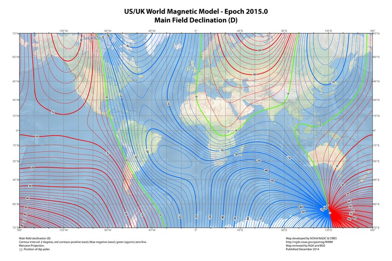 Image source: Wikipedia
Returning to the hiking map for our locality, we might notice that the Magnetic Variation is printed on the map as: 'M.V=5°E', or 'M.V=+5°'. This means that a reading that we take from our compass whilst in the region shown on the map will be out by 5 degrees. The direction is indicated by the letter. 'M.V=5°E', or 'M.V=+5°' is known as an 'Eastward Error'. 'M.V=5°W', or 'M.V=-5°' is known as an 'Westward Error'.
Imagine walking from Point A to Point B on our map. We might use a protractor to see that the bearing on the map from Point A to Point B is 57°. That is a bearing relating to True North, so we call that bearing 57° True. We now need to apply the Magnetic Variation to that bearing. As we are transfering a bearing from Map to Compass, if the Magnetic Variation is 'Eastward', we need to SUBTRACT the value from our True bearing, whilst if the Magnetic Variation is 'Westward', we need to ADD the value to our True bearing. Our Magnetic Variation is 5 degrees Eastward, so we subtract 5 from 57 to get a Magnetic bearing of 52°. If we were to walk from Point A whilst following a compass bearing of 52°, we would eventually get to Point B.
If, however, we were transfering a bearing from Compass to Map, by taking a bearing from a compass and then transferring it to the map, we need to reverse the plus and minus. Imagine Point A was on the top of a mountain, and in the distance we could see Point C. If we take a compass bearing of the direction to Point C, we might read on the compass that it is 128°. To then transfer that to our map by drawing a line from Point A to Point C, we would again apply the Magnetic Variation, but this time if the Magnetic Variation is 'Eastward', we need to ADD the value to our Magnetic bearing, whilst if the Magnetic Variation is 'Westward', we need to SUBTRACT the value from our Magnetic bearing. Our Magnetic Variation is 5 degrees Eastward, so we add 5 to 128 to get a True bearing of 133°. If we were to draw a line on the map from Point A at a bearing of 133°, the line would go through Point C.
 Click the Map to see full sized image (1036 x 793 pixels)
So, how does that apply to maps and software that tell you the position of a country from your QTH? Well, the 'Great Circle Mapper', like most other software, gives bearings in relation to True North (aka Geodetic North). Our Antenna Rotator needs to be aligned to True North, so that the bearings on the map will point the antenna in the same direction. First, we need to power-up the antenna rotator and press the buttons on the controller so that the indicator on the control box reads '000' or North. Next, we need to power-off the controller, and rotate the body of the antenna rotator so it is also pointing to True North. To do this, look at the compass and see where the needle points to North. Point the body of the antenna rotator in that direction too. Then, find the Magnetic Variation for your location. If the variation is 'Eastward' we need to rotate the body of the antenna rotator anti-clockwise (i.e. subtract) by the amount of the variation. If the variation is 'Westward' we need to rotate the body of the antenna rotator clockwise (i.e. add) by the amount of the variation. The body of the antenna rotator will then be pointing to True North, and your beam headings will be correct.
If, however, we already have an antenna in the air, and we want to know what it is pointing at, we must first use our compass to take a bearing by standing at the back and pointing the compass in the direction of the front. Lets say the compass reads 74°. We then find the Magnetic Variation for our location. If the variation is 'Eastward' we need to ADD the value to our Magnetic bearing, whilst if the Magnetic Variation is 'Westward', we need to SUBTRACT the value from our Magnetic bearing. Our Magnetic Variation is 5 degrees Eastward, so we add 5 to 74 to get a True bearing of 79°. If we were to draw a line from the center of our Great Circle Map at a bearing of 79°, we would see what the antenna is pointing at.
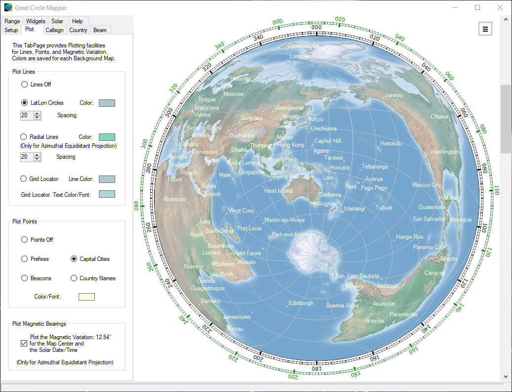
The only thing we need now is to discover what the Magnetic Variation is for our location and a specified date. There are some resources available online, such as the NOAA Magnetic Declination Estimated Value page, or you could just use my 'Great Circle Mapper' program, as it has that facility built in, as well as producing the most attractive Beam Heading maps available. Select the 'Azimuthal Equidistant' projection on the 'Setup' Tab-Page, and then check the 'Plot the Magnetic Variation..' checkbox on the 'Plot' Tab-Page. An extra compass-rose will be added, who's values correspond to the magnetic variation for the position in the center of the map. For an example, click the position of Canberra, the capital city of Australia. When the 'Plot the Magnetic Variation..' checkbox is checked, the magnetic variation for that position (approx. +12°) will show in the label next to the checkbox, and the green compass-rose will have rotated anticlockwise by that amount.
|