VMAP0 Available Data
This page helps to explain the data structure of the VMAP0 libraries.
OK, so we have downloaded a VMAP0 libary, unzipped it, and installed it on our hard-drive. What next ? If you are using the VPFVIEW software, the data structure is hidden from us. Once the 'Feature Selection' window has been mastered, its easy to add or remove features (i.e. different types of information used to build the map) without having to explore the rather complex file-structure of a VPF library. But if we are using one of the other software programs mentioned on the last page, it becomes necessary to hunt for the dataset we require. This page is here to help do that.
Overview
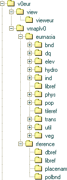
VMap Level 0 libraries are organized into thematic layers. Each VMap thematic layer is stored as a single coverage within a VPF library. There are two reference coverages and ten thematic coverages in the Data Library level, and one reference coverage and three thematic coverages in the Reference Library. The table below shows what each directory contains...
| Structure Level | Thematic Layer | Directory Name |
|---|---|---|
| Data Libraries | Library Reference | libref |
| Tile Reference | tileref | |
| Boundaries | bnd | |
| Data Quality | dq | |
| Elevation | elev | |
| Hydrography | hydro | |
| Industry | ind | |
| Physiography | phys | |
| Population | pop | |
| Transportation | trans | |
| Utilities | util | |
| Vegetation | veg | |
| Reference Library | Library Reference | libref |
| Database Reference | dbref | |
| Political Entities | polbnd | |
| Place Names | placenam |

Exploring
Lets put that information to use by exploring one of the libraries. I will choose v0eur, the library for Europe and North Asia because its first on my hard drive. The other libraries are similar, though its important to note that not every library contains the full set of data layers. For a viewer, I'll use Arc Explorer 2.
Start ArcExplorer, and ignoring the more usual Load and Save dialogs, click on the black '+' sign (Add Themes to View) which opens the Add Themes Explorer. Navigate to the VMAP0 libary, expand all the branches, and you will have a view like the picture on the right. In most cases, Arc Explorer ignores files that it doesn't know what to do with, so we can examine folders and see the usable data displayed. The VMap database contains five types of feature classes as defined by MIL-STD-2407: point, node, line, area, and text. The node feature class is a subtype of the point feature class. The suffixes for each feature class type are :
- Point Feature Table - .pft
- Node Feature Table - .pft
- Line Feature Table - .lft
- Area Feature Table - .aft
- Text Feature Table - .tft
These are the 5 file types that we will use to build maps. Arc Explorer does try to pick out another file type (.rat) but can't actually open it, so you can ignore these. What's left are a variety of semi-meaningless file names: polbndp, aquecanl, cutfill, builtupp, etc. Find out what these are, and we will be able to select the exact data for our map. The table on the next page explains what each one of those file names mean...
VMAP0 Software
VMAP0 Filenames
