 The IARU Grid Locator System. The IARU Grid Locator System.
Grid Squares are being used more and more by Radio Amateurs throughout the world to identify the location of their stations. First proposed at a conference in Maidenhead, England in 1980 (and hence sometimes called Maidenhead Locators), grid squares allow three levels of precision (two, four or six character) to define a station's latitude and longitude. As will be seen by the world map on the next page, the world is divided into a grid of squares that are ten degrees of latitude high by twenty degrees of longitude wide. Each square is identified by a diferent two-letter code. For example, Ireland is in location IO.
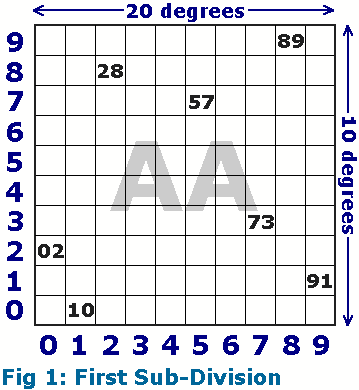 Each of these squares is further divided into 10 on each axis, giving 100 sub-squares, each of which is one degree of latitude high by two degrees of longitude wide. A diagram of this can be seen in Fig. 1. Each of these squares is identified by the two letters of the alphabet from the map above (generally shown in capitals), and two numeric characters. For example, Dublin is in location IO63.
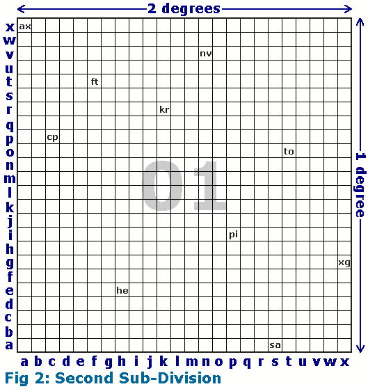
For higher precision, each grid square may be further divided into 24 on each axis, giving 576 sub-squares, each of which is 2.5 minutes of latitude high by 5 minutes of longitude wide. A diagram of this can be seen in Fig. 2. Each of these sub-squares is identified by the two letters of the alphabet and two numeric characters as before, plus two lower-case alphabetical characters. Using this system, a station's location is thus identified to within better than 5.6 nautical miles anywhere on the surface of the Earth. For example, the centre of Dublin, at latitude 53d20m N and longitude 06d16m W, is in location IO63ui.
 The easiest way to find out your own Grid Locator is by using one of the following resources:
- Amsat Grid Conversion Page An online resource on the Amsat website that will convert Latitude/Longitude to Grid, and from Grid back to Latitude/Longitude again.
- Gridconv.zip This 76k zip-file contains Wingrid.exe and Dosgrid.exe, DOS and (16 bit) Windows versions of a simple program that converts between NGR, Maidenhead Locator, QRA, and Latitude/Longitude.
- WinGrid Ver3.6 This program calculates grid squares from latitudes and longitudes, the reverse, and calculates distances and headings from two sets of lat/long or grid squares. The program saves your home QTH information, converts from miles to kilometers, and allows switching between "DD MM SS" and "DD.ddddd" formats.
For a real time display of Grid Locators, visit my Global Overlay Mapper.
To see a World Grid Locator Map, click Here.
To see a map showing the Grid Locator Coverage of Ireland, click Here.
|